Author Archives: sweeneydj

Our first real storm of the winter?

snow

I can see it already in the many, many, tweets and Facebook posts.  There is a LOT of interest in this coming weekend’s storm threat.  Why?  Fans of snow have not had their fix of a classic storm riding up the coast yet and it’s already late January.

Yes, there is growing confidence in a storm.  The details are not yet defined.  At this point, it looks like a storm is likely and it likely takes a snow track.

Not only do we look at the models (euro and gfs) we look at the supporting solutions that accompany those models.  There is still a bit of a “spread” as to where that storm will end up.

As of this update (Monday PM) it doesn’t appear to be a block buster storm, but it does appear to have plenty of snow and wind.


euroensemble

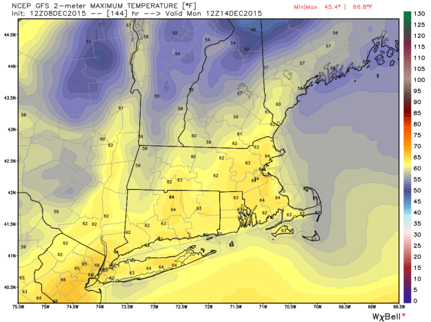
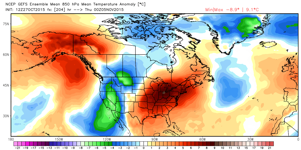
The image above is what we call an “ensemble” forecast.  More than 50 forecasts are “averaged” into a consensus forecast.  As you can see, the consensus is pointing to a large east coast storm.  Again, the details still need to be worked out as we fine tune the forecast.

What we know: A strong storm develops off the mid-Atlantic during the day Saturday into Saturday night, likely ending by Sunday morning.

What do don’t know: How close does the storm track, this will dictate if we see major snow or a lighter snow storm.

When will we know?  We should have a better handle on the storm once we see a few more model runs and look at trends and other factors that could influence the amount of snow for the weekend.

Travel plans?  If you are traveling by car, stay tuned to the forecast as this could have a far reaching impact through the big cities down the coast.

Air travel the best advice is to call your local carrier, find out where your flight is coming from.  Is the plane going to be here Saturday morning?  Is it coming from Baltimore?  That can make a HUGE difference in whether your flight will be impacted.  Airlines won’t fly a plane into a nor’easter if it thinks it could get stuck here.  However, airlines will take off if it means getting a plane out of the path of the storm.  That’s why your originating flight information makes a difference.

Stay tuned for more updates.


Another shot of cold this week.. but snow?

Forecast 7 Day Temp Trend Hartford.png

Snow fans have been clamoring for snow!  We hear you on Facebook, Twitter and email.  Those that are not fans of the real cold are counting the days to spring.

Yes, snow fans, the pattern is looking more favorable (as favorable as it can get with a strong el nino).  As you can see from the image above we’ll have more cold air in place as we head into the new week.

THE FIRST SYSTEM…

The first system we deal with is an Alberta Clipper. A vigorous area of low pressure moving through the Northeast. The problem for southern New England is that it is too far north to be a snow producer for us.  The weak storm will develop into a rather strong storm to our north and east and act as a blocking mechanism for a good portion of next week.  In other words, it switches up the pattern a bit unlike the last few weeks.

Custom Map 5

An Alberta Clipper goes by to our north, but too far north for a big burst of snow here.  Best chance of a snowstorm from this is in Maine.


Forecast 7 Day

The European model (ECMWF) as of Saturday 00z. A LOT can change before next week, but we’re giving you a “First Alert” heads up on the week ahead.

ANOTHER STORM THREAT?

A southern storm will get going but model data is very split on weather it stays south or gets picked up by the jet and becomes a coastal storm threat by Friday/Saturday (see above)

Of course, we will keep you posted as new data comes in.  Follow me on Twitter and Facebook for the latest details.

Record shattering warmth possible..

gfs_t2max_boston_25

Hanukkah has begun and we are just 3 weeks away from the Christmas holiday.  Usually, the holidays has people thinking hot cocoa, snow and lighting a good fire in the fireplace.  Instead, as we move deeper into December our warmer than average fall continues.

We’re looking at a set up this weekend that will be ‘almost’ perfect to get record breaking warmth in here.  “Almost” is only because our wind direction may not be THE most optimal for the warmest temperatures, but we’ll be pretty darn toasty for December standards.

Temps will climb into the 50s for the remainder of the week. By the weekend, a large high will be situated off of the coast and a cold front slicing through the mid-section of the country.  This is a good set up to send warmth our way.

60-65 is likely on Sunday and into the 60s  with increasing rain chances on Monday.  The above graph shows possible temps going into Monday.  The records this weekend including Monday are 60 degrees inland.

There are some signs of decent cool downs here and there, but overall, no sign of the pattern changing in December.  If we can get a storm to meet up with one of these cool downs, we could be in business for a little winter.. so far, no luck.

Snow fans will have to hold on..


Thanksgiving travel looking good.. and warm!

Last year at this time we were tracking a pretty big storm for the busiest travel day of the year (the Wednesday before Thanksgiving).  See my my blog post from last year when we were forecasting over a half of a foot of snow on the busy travel day.

This year, our above average pattern continues to keep us storm free.

What to expect this week:   First a cool down on Monday and Tuesday.  Cold highs only in the low 40’s.

Wednesday-Friday:  Temps will begin to climb.  In fact, by Friday some towns will be close to 60 degrees for highs.  If you’re planning on being out during the busy shopping day it looks downright pleasant.  Check out the jet stream, it cuts well to the north and west by Friday.  That means we’ll see warmer than average temperatures.  By Friday our average high temperature should be right around 47 degrees.  We’re forecasting temps closer toward 60.WVIT Jet Stream

Air Travel:  If you’re traveling by air, you can expect a good chunk of the country to be on the quiet side.  Check out some of the connecting hub forecasts below.

Special Airport Weather1Special Airport Weather


If you’re traveling for the holiday weekend, make it a safe one!

Social media stats show people want to keep the warm fall going!

warmingtrend

A quick post today regarding the photo I posted yesterday.   With Halloween in the rear view mirror, daylight saving time ending and winter looming, people are clearly clamoring to squeeze out as much fall as possible.

This photo above received 2,083 views on Twitter.  The same photo on Facebook garnered 7,044 views (between shares and views on my page Facebook.com/WeatherDarrenSweeney.

My point here, people (sans skiers) are hoping to keep the warmer weather around.  If you like warmth, November looks to be toasty.  Yes, I see some shots of cold here and there, but overall, the trend is for a more warmth than cold.  Check out my previous post Warm November.

It’s still too early to see how the winter will shape up, but El Nino will keep things interesting as the cold air continues to build at the top of the globe and starts heading south.  Stay tuned.

Ready for some warmth? November looks to start well above average!

These are 850 MB temp anomalies.   850 temps are a good indication of what surface temps could be like.  The red means well above average.

These are 850 MB temp anomalies. 850 temps are a good indication of what surface temps could be like. The red means well above average.

It certainly has been a nice fall so far.  We’ve had a couple of very chilly days, but overall we have been sitting average or above since fall began.

With Halloween and November starting this weekend, a lot of people are thinking winter.  Not so fast!

The map above shows us the start of November and it’s looking WARM.  High pressure sitting in the perfect location to pump in the warm air means we’ll be going well above average.

As November starts our average high temperatures drop steadily into the 50s and through the 40s.  By the end of the month our average high temps are in the lower to middle 40s.

A closer view (the map below) shows one more close up example of possible highs next Wednesday. Mid to upper 60s.  I would not be surprised to see 70s next week around here.

Despite turning the clocks back and that earlier sunset, lets not count autumn out just yet.

Possible highs next Wednesday

The climatologically hottest part of summer is over.. but more heat is on the way.

It has been a while since I have blog posted.  Mainly, because the weather has been quiet.

With only 1 heat wave and minimal severe weather, this summer has been fairly average in terms of sun, warmth and just “ok” in the rain department.  We have been overall a bit dry from time to time.

In July, we averaged just over 1″ of rain below average and we were .03 degrees above average.  We also had one heat wave during the month (only heat wave of the summer).

Our average high temperature peaks at 85 in mid to late July and then begins to fall in early August.  Our average high temperature by the end of August will be around 79 degrees.

Looking into next week:  A beautiful stretch of summer weather is on the way, but it will be getting warm.  Temps by early next week will be near 90 Sunday thru Tuesday. We could be nearing our second heat wave of the season but it will be a close call.  A cold front by late Tuesday into Wednesday will likely begin to break to warmest part of the week.

850 temps are a big help in determining high temperatures at the surface. 850 temps are approximately 5000K feet above the ground. 5000K feet high but still a big help in determining surface temps. When forecasting we sometimes start there and then factor in things like wind direction, cloud cover among other things.

850 temps are a big help in determining high temperatures at the surface. 850 temps are approximately 5000K feet above the ground. 5000K feet high but still a big help in determining surface temps. When forecasting we sometimes start there and then factor in things like wind direction, cloud cover among other things.  The above image is for Monday afternoon.  This particular map shows temp deviations above or below average. In our case, the red indicates above average.

I realize many of you have vacation plans to squeeze out the final days of summer  before school begins.  Of course we have to keep in mind summer weather continues well into September.

With just a couple of thunderstorm chances into next week, no big washouts are in the forecast.  our lawns and gardens could use a soaking, but it looks like we’ll stay relatively dry..  Since June, rainfall has been actually OK around here.  The problem with the rain this summer has been that rain has been widely spread out.  Since January, we’re still about 3.5″ of rain below normal.

Enjoy the rest of the summer!

~Darren

DAYLIGHT TRIVIA:  Our sun is now setting before 8PM again and will continue to set earlier each day.  The next time we’re back to 8PM + sunsets is not until May 12, 2016.

The chilly pattern from the winter.. is back.

For those of you who say we go from winter to summer, this pattern ahead will provide PLENTY of cool spring weathe.

Hang on to your spring jackets (heavier ones, too) !

The pattern that has been with us most of the winter, is setting up shop (again). Warm air locked out west, colder air to the east.

How long will it last? Right now it looks like we’re going to see this pattern through early to even mid May. There will be breaks of warmth of course, but overall, it’s going to be a slow process.

Things of the positives. We escape major flooding from fast snowmelt up north. We catch a break before the summer warmth.. trying to find the silver linings here.

The image below shows Saturday (just as an example) how how well below average we will be. Where you see the orange and red, that’s where the spring warmth is.

This graphic shows Saturday's below avg temps, but this is a common map we'll see through early to mid May.

This graphic shows Saturday’s below avg temps, but this is a common map we’ll see through early to mid May.

When will it warm up? There is hope for warmer temperatures

The warmer air has been locked out west since February.  The jet stream looks to flip as we head into next week.

The warmer air has been locked out west since February. The jet stream looks to flip as we head into next week.

Many people are wondering, where the heck is spring?  Temps have been below normal for weeks.  As we head into next week the average high temperature is supposed to be 56 or 57 degrees.  We’ll spend a few days in the 40s!

First things first:  This week will feature several rain chances, along with cold high pressure to our north funneling in cold air.  That means temps will struggle through the 40s through mid-week.

The hope for warmer temps: Take a look at the image below, that is one computer model showing highs in the 60s by next Tuesday.  There is other data that brings in 70s to near 80 degrees.  That’s still questionable, but the bottom line is the pattern looks to flip in our favor next week in terms of warmth.

Despite the fact we have been hoping for warmth, this spring (so far) has been good for a slow meltdown of the snowpack.  There is still a lot of snow to melt up north, but so far the rivers are handling the meltdown.

Patience is key as we head into this week with the prolonged period of showers and cool temps.

The GFS (American Model) showing spring warmth next week

This map shows temps on next Tuesday afternoon in the 60s.

More snow, to ice, to a lull, back to snow? All possible over the next 48 hours

Cold air to the north may dry up some of the snow, causing a sharp cut off between a snowy day (south of us) to more nuisance snow (north)  Something we will have to watch

Cold air to the north may dry up some of the snow, causing a sharp cut off between a snowy day (south of us) to more nuisance snow (north) Something we will have to watch

Tuesday PM Update:  LOTS of questions (and rightly so) on what’s to come for the next 48 hours.  It’s a tough one, as they often times are this time of year.  Especially with the way the cold has been winning out since January (When is the last time we saw a rain drop?  I can’t remember.

This evening:  Snow begins as early as 4PM western CT. Snowing pretty much statewide by 6PM.

Snow comes down moderate to even heavy at times through the evening.Between 8 and 10 (or so) we will start to see a mix to sleet, freezing rain across the state.

Closer to midnight and beyond we see the warmer air start to work in (slowly, first at cloud level and then close to the surface).

By morning, some delays are possible (esp. northern CT) but temps will slowly rise overnight.

THE GOOD NEWS IS.. we’re not expecting heavy rain with this, the heaviest of the precip will fall as snow/ice (better than rain at this point).

By morning temps rising through the low 30s.  We briefly could warm into the low 40s tomorrow, mainly at the shore.

Here’s where it gets interesting:  Colder air will start to work in from the north through the day and through Wednesday evening.  At the same time, moisture is going to work along a stalled front to our south.

The big question is, does the cold dense dry air win out and keep most of the next batch of moisture to the south?

At this point, some additional accumulation is possible on Thursday with snow, but look at the image below, a very sharp cut off between several inches of accumulation across Long Island, compared to some along the shore, little in northern CT.

That is the big detail that needs to be worked out.

Some snow re-develops Thursday morning into the afternoon.
How much is still in question.  At this point, more along the shore (couple of inches?)  But we run a very fine line between a pretty snowy day and not much happening.

The breakdown:
This evening: Snow, to ice, to some rain drops by morning (but not heavy).  2-4″ of accumulation this evening.

Wednesday: a lull, perhaps turning a little milder, in the 30s (40s shore ?)

Wednesday evening/overnight: Turning colder

Thursday AM into the afternoon: The possibility of snow developing (again) some accumulation is possible, especially southern CT.   This is what we’ll be fine tuning as we move forward.