Tag Archives: weather

A one day cold blast on the way

cold_front

A cold front is on the way and you’ll notice its arrival on Friday.

Winds will start gusting late in the day on Friday as the cold air drains into the state.  So far this fall we have been quite mild.  Warm, actually.

Don’t get used to this cold air as it will not stick around.  In fact, our temps on Saturday will be stuck in the 40s with wind chills in the 30s.  By Sunday, we’ll be looking at a temp rebound back into the 50s (seasonably cool).

The long range outlook is signaling a warming trend for much of the country in November.

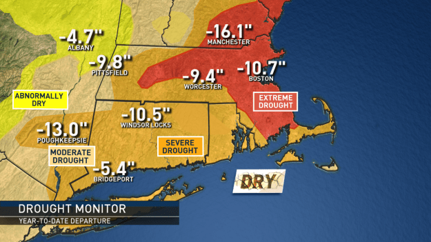
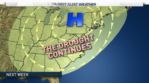
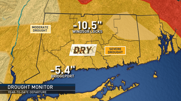
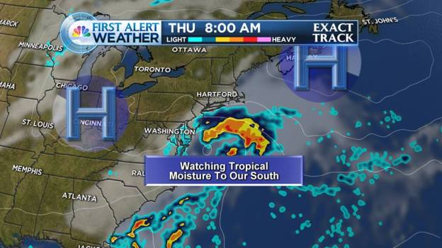
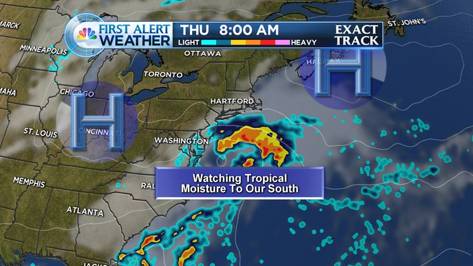
Drought:  We continue to be extremely dry.  The next shot at any appreciable rain will be in the middle of next week.  Models are hinting at a storm, but the data has been inconsistent (at best) on delivering a soaking.  We’ll keep you posted as the models begin to come in line.

Until then, continue to enjoy this typical fall-like feel to the air with plenty of sunshine.


Overall, the dry weather pattern continues…

almanac-drought-monitor-sne

I will be the first to admit that we got more rain than expected from #Matthew.  The moisture moving up the coast was caught up in a cold front and dumped anywhere from .25″ of rain (or less) western CT up to and over 1.50″ of rain eastern areas.

This was not a drought buster (getting several inches of rain in a couple of days would have done us good).  But, we’ll take it.

“Sans tropical systems over the next 7019 days we’re doing back to dry weather”

The problem is, sans tropical systems over the next 7-10 days we’re going back to the very dry weather.  Tree experts have commented on social media that we desperately need the rain in order to protect root systems so we can have a healthy 2017 of budding.  At this point, rainfall looks meager.

Several areas of high pressure will take shape over the next 7-10 days.

custom-map-6

A large area of high pressure sets up this week and another area moves in later this week to reinforce the dry air.

While locally the rain we received on Sunday can only help, I don’t expect these maps to change much when they are updated this week.  The dry weather that will last the next 7-10 will compound the problem.

The best thing we can hope for is a tropical system (albeit weaker than Matthew would be nice) would come ashore and get picked up and streamed to the northeast.  This ALMOST happened with Matthew but a cold front cut the moisture off before it could really get going.

almanac-drought-monitor

A cool (ish) looking start to June ?

cooleasthotwest

The above image shows a set up around June 9th that keeps cool pushes of air coming from the northwest and record heat stuck out west.

The warmer weather is here and that means outdoor events, charity run/walks and of course beach and pool days are being planned in earnest.  What is the start of summer looking like?  Meteo

We have had some very warm days sneaking in before the official start of summer ((The official start of the solstice is June 20 at 6:34 A.M. EDT) but get ready for a pattern change for the rest of the first half of June.  Meteorological summer by the way started June 1.

The set up is going to keep the heat bottled up out west.  We’ll likely see an upper level low keep cooler air funneling in from Canada across the northeast.  This means we’ll likely even see some unsettled weather (showers) from time to time.

The Tropics and Short Term Forecast:

This time of year we always have to keep an eye on the tropics to “disrupt” or influence weather patterns.  At this point the National Hurricane Center is keeping an eye on the Gulf of Mexico and Florida.  There could be an area of low pressure developing some time next week.  What does that mean for us?  At this point, nothing.  However, in the image below (Sunday)  that is a cold front approaching us and it is starting to tap into some of that Gulf of Mexico moisture.  That spells a wet Sunday for us with some embedded heavier downpours into Sunday night.  The next tropical system (if it forms) will be named “Colin”.

gulfisopen

This is Sunday. Notice the rain from New England down to the Gulf. Some of that rain could be heavy at times.


As new data and trends come in for the summer months I will post updates here.  Until then, keep the umbrella close by and close eye on a rather quickly changing weather pattern over the next 1-2 weeks.

Of course, you can follow local updates and weather facts on Twitter and Facebook 

We are in for ANOTHER Monday winter storm, when will it end??

Early snowfall forecast for Sunday evening, night and Monday morning.

Early snowfall forecast for Sunday evening, night and Monday morning.

It’s the weekend, of COURSE we’re tracking.. more snow.

Can you FEEL the sun getting warmer? It’s trying, but winter is just holding on for dear life!  Our average high “should be” around 42 degrees, we have been struggling through the 20s!  Certainly on track for the coldest February EVER!

Here’s the deal with the first few days of March.

It’s the weekend, of COURSE we’re tracking.. more snow.

Can you FEEL the sun getting warmer? It’s trying, but winter is just holding on for dear life!

Here’s the deal with the first few days of March.

Saturday: Sunshine, cold. highs in the 20s. Cold, clear Saturday night.

Sunday: Increasing clouds, a wave of low pressure moves in our direction and we should see snow developing late day or in the evening.

Snow will end on Monday morning, with sunshine by afternoon.

Early call: It is looking something like a 2-4″, 3-6″ snowfall. Not major, but moderate, and messing up the Monday morning commute.

The first week of March looks stormy! We’ll see another storm move in our direction by Tuesday afternoon, this one looks to pull some warm air in here and start as snow but trend to a mix, perhaps some rain? We’ll keep you posted on that.

The bottom line: Snow piles grow even bigger, and our patience shrinks with the winter that seemingly seems never ending.

When will it warm up? I see a ‘blip’ of warmth with that midweek storm, before it gets cold again toward next weekend.

Keep your eyes on St. Patty’s Day, I see ‘some’ warmth by then (appreciable .. but short lived).

Think warm, it will happen, it’s just going to take some time to transition from this record breaking winter.

No rain until October.. except for one bump in the road…

Good morning!
The first morning of fall. I don’t like the summer to end (it’s my favorite season) but I like fall as well.

Yesterday I blogged about an exceptional 7-day forecast with sun sun sun and more sun. If you watched on the air I also talked a little about some tropical moisture we would have to watch just to our south.

10710642_727093820698305_777167955101223351_n

Computer data continues to show rain on our doorstep by Thursday. It’s still going to be a very close call.

High pressure looks expansive and impressive. It’s too soon to know if the moisture will make it here or not.

Right now, it looks like clouds increase on Wednesday night. By Thursday morning we could have a period of rain lurking just to our south.

For a neat look at how all of this evolves in movie form, click here: https://www.facebook.com/video.php?v=727102790697408&set=vb.147485551992471&type=2&theater

No matter what happens with this, it looks like the weekend still looks GREAT! Warming temps, too.

It we do not see any rain on Thursday morning, we will likely stay dry until October. Pretty incredible dry stretch.

Enjoy the sunshine until the Thursday clouds.