It has been a while since I have blog posted. Mainly, because the weather has been quiet.
With only 1 heat wave and minimal severe weather, this summer has been fairly average in terms of sun, warmth and just “ok” in the rain department. We have been overall a bit dry from time to time.
In July, we averaged just over 1″ of rain below average and we were .03 degrees above average. We also had one heat wave during the month (only heat wave of the summer).
Our average high temperature peaks at 85 in mid to late July and then begins to fall in early August. Our average high temperature by the end of August will be around 79 degrees.
Looking into next week: A beautiful stretch of summer weather is on the way, but it will be getting warm. Temps by early next week will be near 90 Sunday thru Tuesday. We could be nearing our second heat wave of the season but it will be a close call. A cold front by late Tuesday into Wednesday will likely begin to break to warmest part of the week.
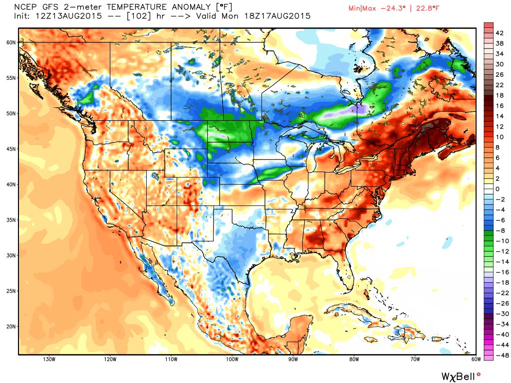
850 temps are a big help in determining high temperatures at the surface. 850 temps are approximately 5000K feet above the ground. 5000K feet high but still a big help in determining surface temps. When forecasting we sometimes start there and then factor in things like wind direction, cloud cover among other things. The above image is for Monday afternoon. This particular map shows temp deviations above or below average. In our case, the red indicates above average.
I realize many of you have vacation plans to squeeze out the final days of summer before school begins. Of course we have to keep in mind summer weather continues well into September.
With just a couple of thunderstorm chances into next week, no big washouts are in the forecast. our lawns and gardens could use a soaking, but it looks like we’ll stay relatively dry.. Since June, rainfall has been actually OK around here. The problem with the rain this summer has been that rain has been widely spread out. Since January, we’re still about 3.5″ of rain below normal.
Enjoy the rest of the summer!
~Darren
DAYLIGHT TRIVIA: Our sun is now setting before 8PM again and will continue to set earlier each day. The next time we’re back to 8PM + sunsets is not until May 12, 2016.