Tag Archives: Connecticut

Overall, the dry weather pattern continues…

almanac-drought-monitor-sne

I will be the first to admit that we got more rain than expected from #Matthew.  The moisture moving up the coast was caught up in a cold front and dumped anywhere from .25″ of rain (or less) western CT up to and over 1.50″ of rain eastern areas.

This was not a drought buster (getting several inches of rain in a couple of days would have done us good).  But, we’ll take it.

“Sans tropical systems over the next 7019 days we’re doing back to dry weather”

The problem is, sans tropical systems over the next 7-10 days we’re going back to the very dry weather.  Tree experts have commented on social media that we desperately need the rain in order to protect root systems so we can have a healthy 2017 of budding.  At this point, rainfall looks meager.

Several areas of high pressure will take shape over the next 7-10 days.

custom-map-6

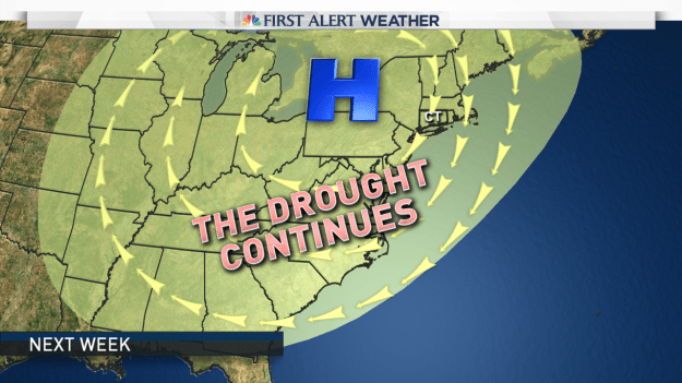
A large area of high pressure sets up this week and another area moves in later this week to reinforce the dry air.

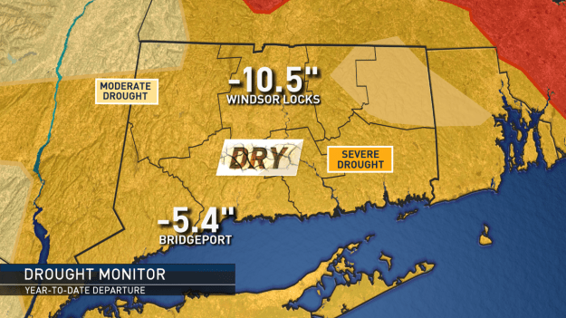
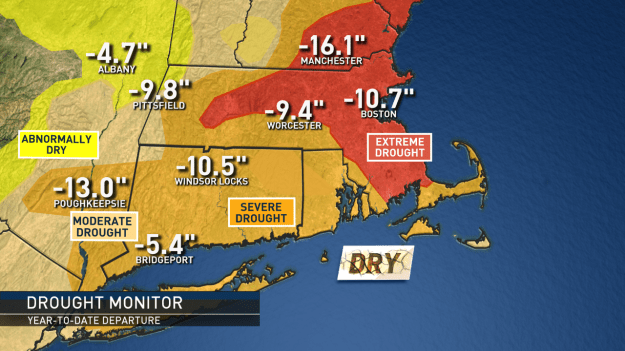
While locally the rain we received on Sunday can only help, I don’t expect these maps to change much when they are updated this week.  The dry weather that will last the next 7-10 will compound the problem.

The best thing we can hope for is a tropical system (albeit weaker than Matthew would be nice) would come ashore and get picked up and streamed to the northeast.  This ALMOST happened with Matthew but a cold front cut the moisture off before it could really get going.

almanac-drought-monitor

A cool (ish) looking start to June ?

cooleasthotwest

The above image shows a set up around June 9th that keeps cool pushes of air coming from the northwest and record heat stuck out west.

The warmer weather is here and that means outdoor events, charity run/walks and of course beach and pool days are being planned in earnest.  What is the start of summer looking like?  Meteo

We have had some very warm days sneaking in before the official start of summer ((The official start of the solstice is June 20 at 6:34 A.M. EDT) but get ready for a pattern change for the rest of the first half of June.  Meteorological summer by the way started June 1.

The set up is going to keep the heat bottled up out west.  We’ll likely see an upper level low keep cooler air funneling in from Canada across the northeast.  This means we’ll likely even see some unsettled weather (showers) from time to time.

The Tropics and Short Term Forecast:

This time of year we always have to keep an eye on the tropics to “disrupt” or influence weather patterns.  At this point the National Hurricane Center is keeping an eye on the Gulf of Mexico and Florida.  There could be an area of low pressure developing some time next week.  What does that mean for us?  At this point, nothing.  However, in the image below (Sunday)  that is a cold front approaching us and it is starting to tap into some of that Gulf of Mexico moisture.  That spells a wet Sunday for us with some embedded heavier downpours into Sunday night.  The next tropical system (if it forms) will be named “Colin”.

gulfisopen

This is Sunday. Notice the rain from New England down to the Gulf. Some of that rain could be heavy at times.


As new data and trends come in for the summer months I will post updates here.  Until then, keep the umbrella close by and close eye on a rather quickly changing weather pattern over the next 1-2 weeks.

Of course, you can follow local updates and weather facts on Twitter and Facebook 

We are in for ANOTHER Monday winter storm, when will it end??

Early snowfall forecast for Sunday evening, night and Monday morning.

Early snowfall forecast for Sunday evening, night and Monday morning.

It’s the weekend, of COURSE we’re tracking.. more snow.

Can you FEEL the sun getting warmer? It’s trying, but winter is just holding on for dear life!  Our average high “should be” around 42 degrees, we have been struggling through the 20s!  Certainly on track for the coldest February EVER!

Here’s the deal with the first few days of March.

It’s the weekend, of COURSE we’re tracking.. more snow.

Can you FEEL the sun getting warmer? It’s trying, but winter is just holding on for dear life!

Here’s the deal with the first few days of March.

Saturday: Sunshine, cold. highs in the 20s. Cold, clear Saturday night.

Sunday: Increasing clouds, a wave of low pressure moves in our direction and we should see snow developing late day or in the evening.

Snow will end on Monday morning, with sunshine by afternoon.

Early call: It is looking something like a 2-4″, 3-6″ snowfall. Not major, but moderate, and messing up the Monday morning commute.

The first week of March looks stormy! We’ll see another storm move in our direction by Tuesday afternoon, this one looks to pull some warm air in here and start as snow but trend to a mix, perhaps some rain? We’ll keep you posted on that.

The bottom line: Snow piles grow even bigger, and our patience shrinks with the winter that seemingly seems never ending.

When will it warm up? I see a ‘blip’ of warmth with that midweek storm, before it gets cold again toward next weekend.

Keep your eyes on St. Patty’s Day, I see ‘some’ warmth by then (appreciable .. but short lived).

Think warm, it will happen, it’s just going to take some time to transition from this record breaking winter.

The next storm threat: Powerful, colder and long duration

Preliminary Storm Threat Details

Our next storm is on the map and here are some quick details to get you.

Monday: Arctic air moves in (something absent from the last storm). Flurries and areas of light snow during the afternoon. Snow starts organizing toward evening as the storm gathers strength.

Monday night thru Tuesday: High wind and a heavy snow threat.
We have the potential for 12+ inches of snow and some data supports DOUBLING that number, along with big time blowing and drifting of the snow. The wind could top 40-50 mph.  The storm will rapidly intensify as well, something we call the storm ‘bombing out’ or Bombogenesis.

Here’s the issue: I’m all about being honest and as clear as possible on social media, when you have a powerful storm they tend to be tightly wound up off the coast. Arctic air also helps to create a sharp “cut off” of heavy snow to little snow. We also have historically had to deal with “dry slots” of air wrapping into the storm here in southern New England cutting down on snow totals.

That being said, the storm has not even taken shape yet and won’t hit the coast until tomorrow morning. Until then we utilize the best data possible. Any slight deviation east or west will make a difference.

The bottom line: Arctic air will be in place, snow will be blowing and drifting and travel by air and car will highly be impacted on Tuesday.

I will keep you posted as new data comes in. Today’s data will help us put some numbers for your hometowns. Right now 1-2feet is the potential.
I have also attached what a “watch” means and what defines a blizzard, just as a refresher since we don’t see that term all too often.

For a movie version of the storm timeline, click HERE: MY FACEBOOK PAGE

Next week: Looking active, but too soon for specifics.

Storm threat #1 to watch for

Storm threat #1 to watch for

Quick Saturday AM Update:  Next week is still looking active, however, at this point, it looks like mostly a rain storm for us, starting perhaps as a wintry mix Monday night and rain and wind on Tuesday.  Will keep you posted of any changes working on in.

If you want to see an animation of the storm, click here: 

Stay with my blog for updates as new information comes in this weekend.


previous discussion__________________________________________________________


Forecasting:  It means to look ahead.  That’s what we do.  Of course, since weather is not an exact science, things change, but we can do our best to keep you posted when we see “signals” of storminess ahead.

We’ve been seeing the hint of “something” in the form of an area of low pressure anytime from late Sunday into Monday night.  It’s not the best set up for wintry precipitation here (although, model data has trended a little colder compared to yesterday).  It bares watching, because it’s slow moving.  It could bring a prolonged period of wind and rain.

For Wednesday

For Wednesday

Whatever happens with the Sunday/Monday system, we’ll have to watch for signs of another coastal low forming after that storm departs. This one (as of right now, and this will change) Looks colder, and favors more wintry precipitation.

As things change and evolve I’ll keep you updated here.  Also, more frequently on TWITTER and FACEBOOK

Increasing confidence for a winter storm on the busiest travel day of the year!

snowmanchester

The GFS model shows a healthy swath of accumulating snow Wednesday evening.

Over the weekend I began talking about a possible storm for the busiest travel day of the year. It is looking more likely that we will see ‘something’ on that day.  In fact, the National Weather Service has issued a Winter Storm Watch (click to see the text from the NWS).

Here are my thoughts::  At this point there is still some model spread as to how close a fairly strong area of low pressure will pass by.  Some model data wants to hug the coast with the storm, which isn’t the best track for all snow.

The Breakdown:  It looks like rain or a rain/snow mix will develop on Wednesday morning.   Snow will be wet to start (especially a mix with rain and sleet along the shore) so accumulating snow may take some time to get going ( (at least on roadways) because temperatures will be on the milder side at the very start.  Once the sun sets and the storm intensifies, temps will drop and the snow will begin to accumulate.   There is a chance we could see 6+ inches of snow especially in northern and n/eastern CT.  The northwest hills will also pile up probably the most snow because accumulating snow will begin sooner there.

Even if you’re not traveling on Wednesday, it tends to be one of the busiest errand days of the year getting ready for the holiday.  Also, about 14,000 of you are registered for the Manchester Road Race on Thanksgiving Morning.   The GOOD news for all of you, the storm will be pulling away by Thursday morning and snow wlll taper during the early morning hours.

How does the storm impact the Macy’s Parade ?  No matter what happens on Wednesday night, the storm will leave us with a mix of clouds and sun on Thanksgiving morning but it will be breezy, the wind could be a problem for the big balloons.

The bottom line:  If you have any travel planned Wednesday morning through Thursday morning, stay tuned to the #FirstAlertCT forecast team.  On this blog, on the web you can find both the text and video First Alert Forecast.      You can also like my my facebook page and twitter page(see the boxes to the right).  CLICK FOLLOW ON THE RIGHT TO FOLLOW THIS BLOG.. It will email you whenever new blog updates are posted.