Author Archives: sweeneydj

We are in for ANOTHER Monday winter storm, when will it end??

Early snowfall forecast for Sunday evening, night and Monday morning.

Early snowfall forecast for Sunday evening, night and Monday morning.

It’s the weekend, of COURSE we’re tracking.. more snow.

Can you FEEL the sun getting warmer? It’s trying, but winter is just holding on for dear life!  Our average high “should be” around 42 degrees, we have been struggling through the 20s!  Certainly on track for the coldest February EVER!

Here’s the deal with the first few days of March.

It’s the weekend, of COURSE we’re tracking.. more snow.

Can you FEEL the sun getting warmer? It’s trying, but winter is just holding on for dear life!

Here’s the deal with the first few days of March.

Saturday: Sunshine, cold. highs in the 20s. Cold, clear Saturday night.

Sunday: Increasing clouds, a wave of low pressure moves in our direction and we should see snow developing late day or in the evening.

Snow will end on Monday morning, with sunshine by afternoon.

Early call: It is looking something like a 2-4″, 3-6″ snowfall. Not major, but moderate, and messing up the Monday morning commute.

The first week of March looks stormy! We’ll see another storm move in our direction by Tuesday afternoon, this one looks to pull some warm air in here and start as snow but trend to a mix, perhaps some rain? We’ll keep you posted on that.

The bottom line: Snow piles grow even bigger, and our patience shrinks with the winter that seemingly seems never ending.

When will it warm up? I see a ‘blip’ of warmth with that midweek storm, before it gets cold again toward next weekend.

Keep your eyes on St. Patty’s Day, I see ‘some’ warmth by then (appreciable .. but short lived).

Think warm, it will happen, it’s just going to take some time to transition from this record breaking winter.

Complex scenario for the next couple of days: More snow!

A front settling to our south will act as the focus point for several rounds of snow

A front settling to our south will act as the focus point for several rounds of snow

This set up is not the norm. The best I can compare this to is when a front stalls during the summer and we get a couple of days of on and off rain, some heavier bouts, some lighter.

Here’s the breakdown:

Today: A few periods of light snow or flurries (especially mid to late morning). Coating, inch? possible.
Tonight/Sunday: Same deal, inch or two likely, some town northern CT pick up 3″.
 Sunday night/Monday: A more impressive batch of moisture moves in, several inches of snow is likely. Right now, it appears the heaviest band will settle north of here (foot plus amounts) but it’s close by, Western Mass.
Still, light to moderate snow is possible for much of the day, which could mean another day of interrupted school and travel.  There could be ice mixing in at the shore as some warmer air tries to move in.
Several inches falling through the day (could top 6″ especially northern CT) doesn’t mean a big blockbuster storm, but we’re starting to ‘inch’ our way to roof concerns, even bigger parking problems in the cities and towns with massive snow piles.

Keep in mind, we’re going to have to keep a running tally.. if we get an inch saturday, couple Sunday and 6 ish Monday, add it all up and it’s impressive nonetheless (see map).

This is total snowfall after several rounds of snow, the heaviest coming late Sunday night into Monday

This is total snowfall after several rounds of snow, the heaviest coming late Sunday night into Monday

The power of social media and weather forecasting

I simply typed in Blizzard of 2015 snowfall forecast, and this is what I got. No wonder the public is so confused.

I simply typed in Blizzard of 2015 snowfall forecast, and this is what I got. No wonder the public is so confused.

While we catch a breather from our “blizzard” (and I only put it in quotes because some of us saw one, some of us did not), it’s time to start getting the word out on how to get a reliable forecast (cutting through the clutter).

MANY folks in CT are upset that we did not see 30 inches of snow.  Some are happy.  Some DID see 30″ of snow.

Social media went nuts (as usual) on the fact huge snow numbers that were being tossed around (even by the National Weather Service offices).   Who do you trust?

My best advice is to find someone that you can rely on (locally) that you know gives you accurate information.  This storm was NOT easy to forecast, although if you saw the forecasts from everyone it looked like a “lock”.  Some were irresponsible by broadcasting really huge numbers without context.  If you put out huge numbers, you should also explain the forecast challenges so people are aware.

I worked on Sunday morning and saw all of the numbers coming in. I wasn’t “sold” on the 30 inch snowstorm from NYC to Boston. I was sold on SOMEONE getting 30″‘s.  We HAD to get that information out there so people were prepared, but I specifically said the following:

For example:  My blog said this on Sunday after looking at the latest data (this was also my message on the air).

“Here’s the issue: I’m all about being honest and as clear as possible on social media, when you have a powerful storm they tend to be tightly wound up off the coast. Arctic air also helps to create a sharp “cut off” of heavy snow to little snow. We also have historically had to deal with “dry slots” of air wrapping into the storm here in southern New England cutting down on snow totals.

That being said, the storm has not even taken shape yet and won’t hit the coast until tomorrow morning. Until then we utilize the best data possible. Any slight deviation east or west will make a difference.”

It was the forecast as I saw it.  It goes back to the fact that weather is not an exact science.  Some treat it as it is… even some meteorologists treat it as such, which in my opinion isn’t responsible to the public.

I put that disclaimer on my forecast, not as an insurance policy, I did it because based on my experience, I have seen this happen before and there were some signals in the data that this was going to be the case.  I am NOT saying I am always right and I’ll be the first to say I’ve blown a forecast before. I’m not ashamed.  It happens.  The fact of the matter is, we get it right more than we get it wrong.   I got a few emails about how we nailed Saturday’s storm, but I got MANY responses about Tuesday not being right. It’s just like at a restaurant.  You get a bad meal or service and you complain.  Most of the time when you leave happy, you say nothing.  It’s the same thing with TV weather forecasting.

Find a couple of local people you trust, follow their blogs, follow their thoughts on Twitter and Facebook and you will be just fine.

The clutter on social media isn’t going to go away.  It’s going to get worse.  The irresponsible broadcasting by some isn’t going to disappear either (one local forecaster put a map on the air that advertised places like Middletown CT were going to get over 40 inches).  What?  It’s now up to YOU to cut through it all by cutting out the fat (per se) by only looking for the best sources.

It’s unfortunate that YOU the consumer have to do this, but it’s the only way.  EVERYONE has the ability to post forecasts (some of the these alarmist sites that look professional are run by 13 year olds).

Onto the next storm (which could impact Superbowl Sunday night and Monday .. btw.  more to come.

Remember to click wisely and stay informed.  it’s the only thing you can do when severe weather happens.

Darren

Blizzard of 2015!

Latest snowfall update

Here are the latest details on the storm:

The storm will be a bust in places like NYC (but we said all along there was going to be a SHARP cut off in the snow and that’s what we saw in western CT and NYC).

I think the far northwest hills will struggle toward the 10″ mark (probably somewhere between 5-10.

The best chance for 20+ totals are going to be in the eastern half of the state and into eastern Mass.  MAJOR drifting in the storm. 3-4FEET in some locales.

I talked about the sharp cut off and other such forecasting issues with this storm on my Facebook page, click here and “like” to add those updates in your feed.CLICK HERE

Thanks for checking out my blog and stay safe.

The next storm threat: Powerful, colder and long duration

Preliminary Storm Threat Details

Our next storm is on the map and here are some quick details to get you.

Monday: Arctic air moves in (something absent from the last storm). Flurries and areas of light snow during the afternoon. Snow starts organizing toward evening as the storm gathers strength.

Monday night thru Tuesday: High wind and a heavy snow threat.
We have the potential for 12+ inches of snow and some data supports DOUBLING that number, along with big time blowing and drifting of the snow. The wind could top 40-50 mph.  The storm will rapidly intensify as well, something we call the storm ‘bombing out’ or Bombogenesis.

Here’s the issue: I’m all about being honest and as clear as possible on social media, when you have a powerful storm they tend to be tightly wound up off the coast. Arctic air also helps to create a sharp “cut off” of heavy snow to little snow. We also have historically had to deal with “dry slots” of air wrapping into the storm here in southern New England cutting down on snow totals.

That being said, the storm has not even taken shape yet and won’t hit the coast until tomorrow morning. Until then we utilize the best data possible. Any slight deviation east or west will make a difference.

The bottom line: Arctic air will be in place, snow will be blowing and drifting and travel by air and car will highly be impacted on Tuesday.

I will keep you posted as new data comes in. Today’s data will help us put some numbers for your hometowns. Right now 1-2feet is the potential.
I have also attached what a “watch” means and what defines a blizzard, just as a refresher since we don’t see that term all too often.

For a movie version of the storm timeline, click HERE: MY FACEBOOK PAGE

Dreaming of a white Christmas here in Connecticut? ( Keep dreaming)

Means the storm goes west and warmer air is pulled in from the south.

Means the storm goes west and warmer air is pulled in from the south.

The data has been very consistent for a while now, on a big storm near the Christmas holiday.  The unfortunate thing (for snow lovers) is that this storm is what we call an “inside runner”.  That means the storm will go west of us and pull in warm air.

In fact, we may see temps near 60 with heavy rain, gusty winds and even a thunderstorm passing through Christmas eve night.

I expect the rain to peak overnight Christmas night.  This is an estimate from the HPC on how much rain can fall.  We’re talking 1-3 inches of rain across the state.

It turns windy and colder on Christmas Day, temps dropping through the 40s.  We could see a few flurries pass through, that’s about it.

Happy Holidays!

A strong Nor’easter is on the way! Get the sump pumps ready!

1-3" of rain expected Tomorrow into tomorrow night.

1-3″ of rain expected Tomorrow into tomorrow night.

As I posted last week and updated over the weekend, a strong coastal storm is expected to form and move up the coast.

Multiple advisories are in place, from Winter weather, coastl flood, flood watches, wind and more.  See ALL advisories here:  ADVISORIES/WATCHES/WARNINGS

The details:  The wind pattern will help to pull the storm close to the coast, that means we’ll see warmer ocean air dominate the storm.  A wintry mix will likely break out tonight, but trend toward rain quickly.

Wintry Mix: It sure is cold today, but expect the atmosphere to slowly warm.  We could start with some freezing drizzle tonight and some scattered areas of light snow breaking out.  As the heavier precip moves in expect a change to rain.  Before that happens, expect plenty of slippery travel during the overnight and likely for the start of the AM commute.

Rain:  Expect heavy rain, with 1-3″+ inches possible.  Check your sump pumps, this is the time of year we see big basement flooding with storms like this, thanks to frozen ground (the water has no where to go, except basements, streets, etc.)

Wind:  Wind gusts will peak during the Tuesday and Tuesday night time frame with gusts frequently 20-40 MPH.  Higher gusts are likely.

The storm (the upper level low) will basically stall across the northeast this week, that means plenty of clouds, on and off rain and snow showers.   By far, the biggest part of the storm will take place Tuesday and Tuesday night.

See the above map for expected rainfall.  Also, you may want to check the sump pumps, this time of year we have the issue of frozen ground and heavy rain.  That combo sends water into basements, etc.  Also a good time to clear storm drains of leaves.

It’s going to be a classic rain storm, with some heavy snow JUST up to our north.

Next week: Looking active, but too soon for specifics.

Storm threat #1 to watch for

Storm threat #1 to watch for

Quick Saturday AM Update:  Next week is still looking active, however, at this point, it looks like mostly a rain storm for us, starting perhaps as a wintry mix Monday night and rain and wind on Tuesday.  Will keep you posted of any changes working on in.

If you want to see an animation of the storm, click here: 

Stay with my blog for updates as new information comes in this weekend.


previous discussion__________________________________________________________


Forecasting:  It means to look ahead.  That’s what we do.  Of course, since weather is not an exact science, things change, but we can do our best to keep you posted when we see “signals” of storminess ahead.

We’ve been seeing the hint of “something” in the form of an area of low pressure anytime from late Sunday into Monday night.  It’s not the best set up for wintry precipitation here (although, model data has trended a little colder compared to yesterday).  It bares watching, because it’s slow moving.  It could bring a prolonged period of wind and rain.

For Wednesday

For Wednesday

Whatever happens with the Sunday/Monday system, we’ll have to watch for signs of another coastal low forming after that storm departs. This one (as of right now, and this will change) Looks colder, and favors more wintry precipitation.

As things change and evolve I’ll keep you updated here.  Also, more frequently on TWITTER and FACEBOOK

A light mix to start the evening, but the mild air will win out in the end…

630pmmixedprecip


Tuesday night:  Just as the cold starts to settle in, warmer air is going to make a move at us.  As that warmer air moves up and over the colder air at the surface we’ll see a wintry mix break out across the state.    At of this typing the warm air intrusion is pretty significant, but I can’t ignore the fact the cold is pretty impressive, too.  A light mix of snow and sleet and even some freezing rain is possible, but not going to be a widespread deal.  Many places won’t see any accumulation, a coating is possible though.

The above image shows snow and or a wintry mix breaking out across the state during the early evening.  Rain will likely fall along the shore.  This will go for a few hours with light snow and or mixed precipitation inland and a fairly quick change to rain along the coast.  Eventually, that change to rain and or some drizzle will work inland toward morning.  The biggest issues of slick roads will be north and west of Hartford.

Wednesday AM:  The warm air will be overtaking the state, rising through the 30s/40s inland and 50 or so along the shore.

Wednesday:  Remember how I told you the warm air will win out?  We’re eventually back to milder air by Wednesday afternoon.

The rest of the week: looks seasonable with temps in the lower to middle 40s.

\We’ll stop the roller coaster ride from warm to cold to warm… with a return to seasonable temps toward the end of the week.

Pre-Thanksgiving Snow: WED EVENING UPDATE!

Please read the details below to find out if you're on the higher end of the scale or lower end.

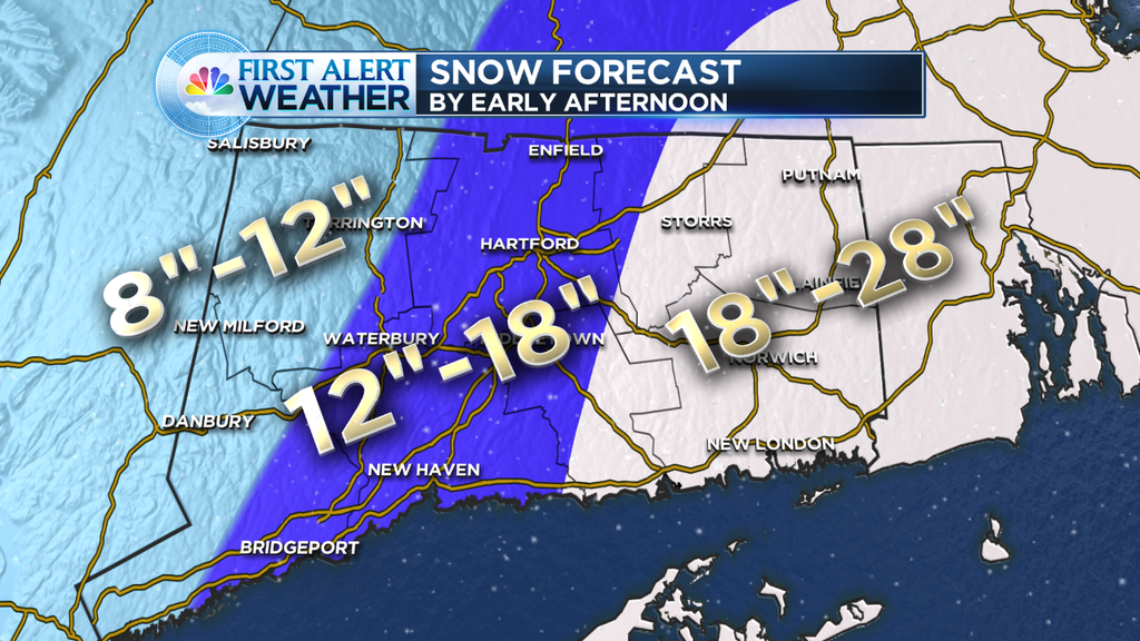
Please read the details below to find out if you’re on the higher end of the scale or lower end.

Wednesday evening update:  Good evening folks:

The roads are a mess in many locations and we’re dealing with power outages in in towns that are now adding up the totals over a half a foot.

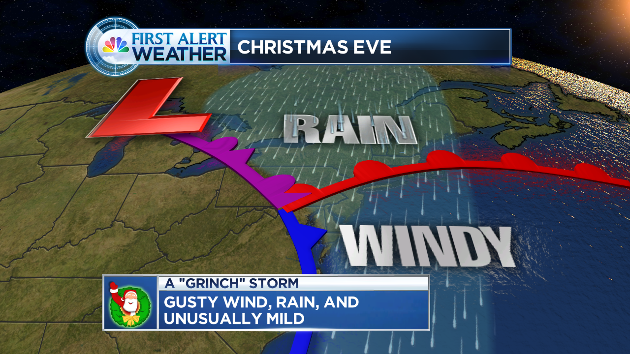
The rest of the evening:  If you’re seeing a change to rain/sleet inland, expect a gradual transition back to snow through the evening  Shoreline, it will be tough to get the cold air to change you over that far south,  but you too may see some snow before all is said and done.  NW HILLS, you keep with snow, thus adding up the most.

Some of you are saying “I live in the 4-8 zone and I don’t have much”, this is really elevation dependent stuff.  Some towns are going to get disappointing totals, but in a situation like this, we have to go with the worst numbers in zones, the map would be way too confusing to take elevation into account in forecasting amounts.  The best is to read detailed discussions like this one to explain the maps.  We do our best to cover every corner of the state.

When does it end?  The heaviest winds down this evening and shortly after midnight the precip will exit to the north and east.  By wake up time tomorrow, we’re talking about clouds, perhaps a lingering flurry, some slick spots from a refreeze overnight, otherwise a quiet Thanksgiving (besides the hum of snow blowers in some towns).

If you have to drive this evening, be safe!


Wednesday PM UPDATE:

We are closing in on the storm and fine tuning the details.

I have posted the total snow accumulation map.  Here’s the deal.

The colder air is currently moving in as of this typing.  That means many of you have already turned over to snow and a moderate to heavy accumulating snow.

The breakdown:  moderate to heavy snow accumulates and messes up roadways over the next few hours.  South and east and along the shore, a mix of rain/sleet/snow will make for mainly wet roadways.

The big issue:  Is going to be a changeover to sleet this afternoon.  IF the sleet starts early, we will be on the lower end of our forecast scale (above), if it comes in a little later, we will add a little more to the totals.  How much will you get?  Take a look at our map, if you flip over to sleet early and miss out on the burst of snow right now, expect lower totals.

This evening: Everyone will trend over to another period of snow and that’s when things will become extra slippery (after dark).  We could see some slick spots even down to the 95 corridor, but SE CT may stay all rain for the most part through this storm.

When does it end:  mix/snow/rain will start to wind down after midnight.  The sleet/rain mixture will trend back to snow during the evening and end after midnight (2-5AM tapering off).  If roadways improve when the mix begins this afternoon, things will get slick again late evening and overnight.

We will be on air all day, can’t watch? Follow me on twitter and facebook (see the boxes to the right) and I will keep you posted.

_______________________________________________________________________________


Wednesday AM Update:  We still expect accumuulating snow, but I want to stress we will likely fall on the lower end 6-10″ NW Hills, 2-6″ Central CT, slushy accumulation SE CT, .  Most of what falls this morning will be rain (outside of the hill towns).  As we go through the day more and more snow will mix in and then we’ll transition over to some snow.

Hartford area: Likely around 3-4 inches of snow when all is said and done.

Hill towns:  Likely ending up 8-10″ marks

Southern and SE CT:  I expect the snow amounts to get lower as you move south and east.  Probably a slushy inch or two and in SE CT, likely mostly rain.

The bottom line is, the model trends overnight, a little warmer, not colder.  Think lower end totals of the map you see above… but still messy.

Tuesday PM Update:  Model data coming in shows a slight shift to the west.  Which means we’ll have to deal with more mild air working into the storm.   I would say this, while I would probably be inclined to lower amounts south of 84, I still think we are dealing with a bunch of moisture.  If this were January we would be talking over a foot easily for many.  My point is, I think we lose a lot to mixing, especially for the first part of the storm, but we should still have a few hours of moderate accumulating snow, especially into the evenings.  I also think some hill towns will come away with more.   This is a typical tough November storm to forecast (without arctic air in place).  Stay tuned for updates!


We have been talking about this since last week.  I have to be honest, the “Euro” was one of the models that first picked up on the storm.  All models are now in line with a messy Wednesday.

The Details: Snow or a mix begins Wednesday morning.  If you have errands to run it may be “precipitating” at 9AM but still passable.  We may begin with a burst of rain in many locations (outside of the hills)  but as the precipitation gets heavier, we pull down colder air and we see the changeover to snow.  We also see snowfall rates begin to pick up.

You will likely see people posting maps of 12+ inches of snow.  That’s because ‘on paper’ there is a ton of moisture being thrown our way.  But at the same time, there are factors working against “maximizing” snowfall.  Some data shows temps (outside of the hilltowns) flirting with freezing for the duration of the storm.  If this were January and there was a cold high to the north, we would be easily talking about over a foot of snow in many locations.

-Warmer temps (surface, aloft)

-Some original melting because of such warm weather today

-wetter snow (due to the warmer temps) but also some mixing (especially southern CT)

Notice the mix southern CT, but also the deep blue indicating the moderate to heavier snow.

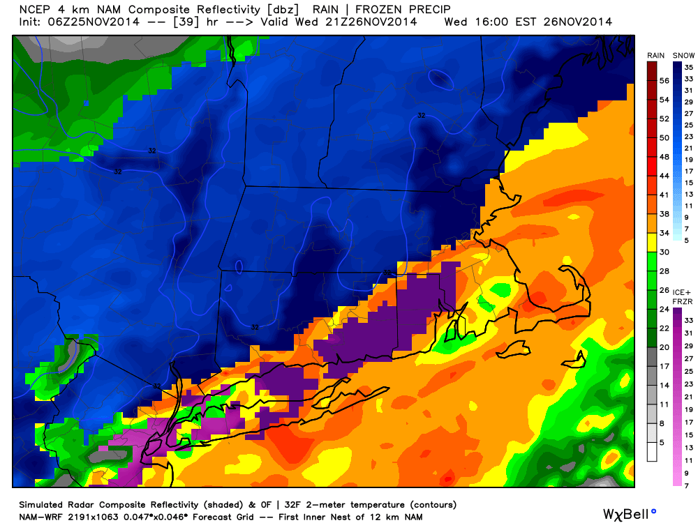
Notice the mix southern CT, but also the deep blue indicating the moderate to heavier snow. at 6PM

The map above shows the mixing issue which is possible in southern CT.   All of this said, we’re still confident in the snowfall forecast.  Could there be a litlte more in spots? yes, a little less where it really mixes, yes.  Overall, a plowable snowfall for much of the state.

The Bottom Line:

-It all begins 7-10AM Wednesday morning (burst of a mix, rain, sleet, snow) depends on where you are.  Errands should be OK first thing in the morning.

-After 11AM precipitation starts going over to snow in most places and picks up in intensity.

– You want to be at your destination by afternoon, as when the sun sets the snow begins to pile up and travel becomes difficult.

Snow will end between Midnight- 3AM, Therefore, besides some shoveling and clean up for Thursday (and the typical wet sloppy roads)  Thanksgiving looks cold, breezy with clouds and sun mixed.   The Manchester Road Race:  Crews will have a lot of time to clean up the roads before runners hit the pavement.

If there are changes, I will post them here.  May the holiday rush begin (early) …