Author Archives: sweeneydj

Extreme cold by next weekend (another storm, too)


image1.png

THIS IS A MAP OF 850 MB HIGHS FOR FRIDAY MORNING.  850’S GIVE METEOROLOGISTS A GOOD FIRST GLANCE AT WHAT SURFACE TEMPS CAN BE LIKE.

Get ready for “dead of winter cold” moving in this week.

I have posted an 850 MB height chart for Friday.  -20 or lower heights is VERY impressive for this time of year.  Remember last December?  We had temps in the 60s to near 70 nearing Christmas.


This blast of cold will be short-lived, though.  We’ll see highs struggle into the 20s both Thursday and Friday.  Wind chill values will likely be in the single digits.  That is COLD for this time of year (Winter officially has not started yet).

Another storm?

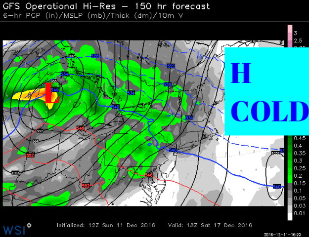
Also, next weekend is the weekend before the Christmas holiday.  We’ll be tracking another storm.  I have posted the GFS and Euro computer models.  They have been consistent in showing a storm track to our north.  That means we’ll have very cold air in place.  The storm track to our north will pull in warmer air from the south.   That means another round of snow over to a wintry mix scenario during the day on Saturday.

It’s way too early to speculate on amounts of specific impacts.

image3image2

Warming trend for Christmas

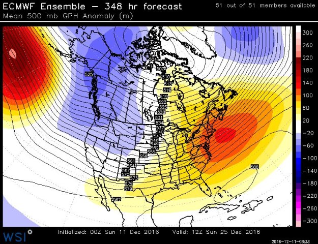
If you’re dreaming of a white Christmas the pattern shift for the second half of the month does not look good for snow.  A pattern flip to colder in the west warmer in the east is looking likely.  Take a look at the model map below.  While I cannot commit to another 69- degree high for Christmas Eve like last year, but it is looking milder than normal as the holiday approaches.

czzb3_bukaaa_11-jpg-large


MUCH needed rain is in the forecast


almanac-drought-monitor

The latest drought monitor update (updated every Tuesday). This map will likely be somewhat improved for next week after this week’s soaking.

A very warm and very dry pattern this summer has continued into fall.  This has not helped our drought situation across the state.

The map above outlines just how severe/extreme the drought has become.  This drought monitor takes rainfall deficit and also includes factors like length of time between a soaking rain and a more long-term impact of a continuing deficit.

Over the next few days, we  have a good chance of seeing at least a moderate soaking across the state.  The soaking rain looks to come in two waves.  Tuesday into Wednesday and then later Wednesday into Thursday.

gfs_tprecip_boston_17

Following this area of rain, the weather pattern looks to go back to seasonably cool and dry weather into the weekend.  For now, big cold and snow chances are on hold.


A one day cold blast on the way

cold_front

A cold front is on the way and you’ll notice its arrival on Friday.

Winds will start gusting late in the day on Friday as the cold air drains into the state.  So far this fall we have been quite mild.  Warm, actually.

Don’t get used to this cold air as it will not stick around.  In fact, our temps on Saturday will be stuck in the 40s with wind chills in the 30s.  By Sunday, we’ll be looking at a temp rebound back into the 50s (seasonably cool).

The long range outlook is signaling a warming trend for much of the country in November.

Drought:  We continue to be extremely dry.  The next shot at any appreciable rain will be in the middle of next week.  Models are hinting at a storm, but the data has been inconsistent (at best) on delivering a soaking.  We’ll keep you posted as the models begin to come in line.

Until then, continue to enjoy this typical fall-like feel to the air with plenty of sunshine.


Overall, the dry weather pattern continues…

almanac-drought-monitor-sne

I will be the first to admit that we got more rain than expected from #Matthew.  The moisture moving up the coast was caught up in a cold front and dumped anywhere from .25″ of rain (or less) western CT up to and over 1.50″ of rain eastern areas.

This was not a drought buster (getting several inches of rain in a couple of days would have done us good).  But, we’ll take it.

“Sans tropical systems over the next 7019 days we’re doing back to dry weather”

The problem is, sans tropical systems over the next 7-10 days we’re going back to the very dry weather.  Tree experts have commented on social media that we desperately need the rain in order to protect root systems so we can have a healthy 2017 of budding.  At this point, rainfall looks meager.

Several areas of high pressure will take shape over the next 7-10 days.

custom-map-6

A large area of high pressure sets up this week and another area moves in later this week to reinforce the dry air.

While locally the rain we received on Sunday can only help, I don’t expect these maps to change much when they are updated this week.  The dry weather that will last the next 7-10 will compound the problem.

The best thing we can hope for is a tropical system (albeit weaker than Matthew would be nice) would come ashore and get picked up and streamed to the northeast.  This ALMOST happened with Matthew but a cold front cut the moisture off before it could really get going.

almanac-drought-monitor

EXTREME.. The only way to describe it

shutterstock_1389321381


MANY have been reaching out on social media and via email to ask, why does it FEEL so hot?  The answer is simple. It’s the amount of moisture in the air that is making it feel “extreme”.

If it feels out of the ordinary, that is because it is.  We don’t normally keep dew point temperatures in the mid and upper 70s sans tropical storms and hurricanes.  The basic set up from last week (the position of the high off the coast and low pressure in the south) basically took the air over the tropics and brought it north.

Dew point numbers are normally locked into the mid 70s in South Florida this time of year.  If you’re wondering what it feels like to live there, that is the kind of weather we have been experiencing here the last couple of days.

For example take a look at the dew point forecast for South Florida and the Keys for Saturday.


gfs_dew2m_miami_6

Dew point forecast (GFS) For Saturday in South Florida


now take a look at the dew point forecast for Connecticut.  Gross, is the only way to describe it.  We will have dew points (see image below) in the mid and upper 70s with some relief on Sunday and Monday.

gfs_dew2m_boston_7

The GFS dew point forecast for New England on Saturday.


Until then, we can’t stress enough, lots of water and if you have respiratory issues, it will be important to stay near AC or find some if you can.  Local cooling shelters will be open for those who don’t have a way to stay cool.

Relief in sight?  Sort of.  Take a look at Tuesday (below).  Notice the 50’s for dew point temps, that will feel REFRESHING!  However, it will not stick around, the tropical air makes a return to the middle and end of next week.

gfs_dew2m_boston_19

The GFS dew point forecast for Tuesday. Note the 50’s for dew points (refreshing)

If you are a summer fan, you are certainly getting your fair share of summer warmth!  Keep in mind, we have already, climatologically, reached our maximum high temp for the year.  Our average high was 85 but we’re now falling through the low 80s.  It’s all down from here.  But.. as you can see by the temps in the 90s this week, average is .. just an average.

Stay cool.


The Heat Is ON!

gfs_t2max_east2_15

This is the GFS late Sunday showing the widespread heat across the country

If you are a fan of summer heat, the pattern over the next week or so supports 90+ degree temperatures for a good part of the country (and here in the northeast).

While some of our air may be tempered a bit (at times) from ‘some’ cooling from the north (low 90’s opposed to mid or upper 90’s)  the pattern looks to lock in and not let go for some time.

Starting Friday, we’ll likely begin a string of 90+ degree days.

The image below depicts one example (Tuesday) where temps could soar into the middle and upper 90’s.  At times (especially on Sunday)  the shoreline will also share in the heat with a wind that will come from land (opposed to a cooling sea breeze).

gfs_t2max_boston_22

The GFS on Tuesday afternoon

“It’s not the heat.. it’s the humidity”

We hear this phrase often times during the summer months. This week, it really is going to be about the humidity making all of the difference.  The image below depicts a rising dew point (the measure of the amount of moisture in the air) by Monday into Tuesday.  Anything over 60 you start to feel.  65+ and it’s downright humid.  Close to 70 and it’s tropical.  Take a look at Monday.  It’s going to feel like Key West in Connecticut.

gfs_dew2m_boston_21.png

The GFS by late Monday into Tuesday showing tropical air over the Northeast.

Well into next week it looks like we’re stuck in the dog days of summer.  This is climatologically speaking the warmest part of the summer season.  Summer fans, soak it in.

A cool (ish) looking start to June ?

cooleasthotwest

The above image shows a set up around June 9th that keeps cool pushes of air coming from the northwest and record heat stuck out west.

The warmer weather is here and that means outdoor events, charity run/walks and of course beach and pool days are being planned in earnest.  What is the start of summer looking like?  Meteo

We have had some very warm days sneaking in before the official start of summer ((The official start of the solstice is June 20 at 6:34 A.M. EDT) but get ready for a pattern change for the rest of the first half of June.  Meteorological summer by the way started June 1.

The set up is going to keep the heat bottled up out west.  We’ll likely see an upper level low keep cooler air funneling in from Canada across the northeast.  This means we’ll likely even see some unsettled weather (showers) from time to time.

The Tropics and Short Term Forecast:

This time of year we always have to keep an eye on the tropics to “disrupt” or influence weather patterns.  At this point the National Hurricane Center is keeping an eye on the Gulf of Mexico and Florida.  There could be an area of low pressure developing some time next week.  What does that mean for us?  At this point, nothing.  However, in the image below (Sunday)  that is a cold front approaching us and it is starting to tap into some of that Gulf of Mexico moisture.  That spells a wet Sunday for us with some embedded heavier downpours into Sunday night.  The next tropical system (if it forms) will be named “Colin”.

gulfisopen

This is Sunday. Notice the rain from New England down to the Gulf. Some of that rain could be heavy at times.


As new data and trends come in for the summer months I will post updates here.  Until then, keep the umbrella close by and close eye on a rather quickly changing weather pattern over the next 1-2 weeks.

Of course, you can follow local updates and weather facts on Twitter and Facebook 

Winter’s last gasp?

We’re on par for one of the warmest winters on record.

Last year at this time we had snow banks so high we couldn’t see over them.  We also had some of the coldest weather we’ve experienced and it was relentless.

greenwichpatch

Winter 2015 would not quit, relentless snow and cold through March. Photo credit: Greenwich Patch

This year, obviously, El Nino had an impact on our winter (as expected).

Are we done with snow?  I don’t think so.  Not yet.

March 1 begins “Meteorological spring”.  We’ll be feeling like spring over the first few days of March, but a change to colder looks likely toward the first weekend of March.

It’s looking like we’ll have a few shots of cold going into March, but overall it looks like the month will end up above average.  The image below shows the NCEP outlook for March.

ncep

It does look like (according to the ‘euro’) and other support that we could see some real above average days through the month, outside of the one of two cold shots we could see.

The thing to watch for is storm track in March.  Especially this March.  An active southern jet stream (which is typical in an el nino winter) could easily meet up with one of those cold shots of air and spawn a big storm.  Remember, the “1993 Storm of the Century” or “Super storm” occurred in March.

Overall, we have turned the corner on winter.  The days are getting longer.

-We turn our clocks ahead on Sunday, March 13.  

-Spring begins Sunday March 20

Our average high temp March 1 =42°

Our average high temp March 31 =54° 

If you’re a snow fan, the best I can do is show you some photos of last year’s epic snow and cold


Big storm/snow trending south…

gfs_6hr_snow_acc_nyc_12
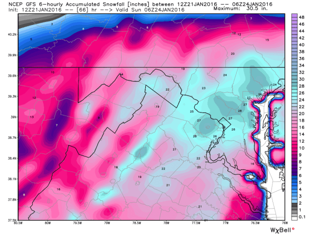
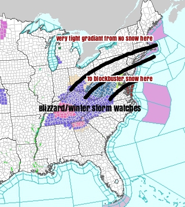
A quick update on the big nor’easter that will really start taking shape over the next 24-36 hours.

Model trends have been for the storm to tick south.  This is something we have said ALL ALONG could happen.  This is why anyone throwing out snowfall numbers starting on Monday was doing a disservice to the viewing/reading public.

Notice in the image above possible snowfall from the storm.  Nothing Hartford, inch or two New Haven to several inches of snow NYC.  Check out double digit snowfall potential in New Jersey.  That is a VERY sharp cut off in precip.

The cause of the sharp cut-off?  A strong, cold area of high pressure (dry air) is banked to our north.  It is also stuck there thanks to the upper level wind pattern.  The ironic thing is for snow fans, this is something that has been absent all winter causing rain storms rather than snow storms.

Can the storm still shift?  YES.  If it shifts even 40, 70 miles, that would make a BIG difference for many towns on Saturday.

WHAT YOU NEED TO KNOW:  It may take until the afternoon to get any snow in northern CT, where as Southern CT could start the snow during the morning (especially through Fairfield County).  Any snow that does happen, likely ends by Sunday morning. 

Northern CT may need a broom to clear snow. People through the shoreline could still be looking at a plowable snow (Plowable generally means  2″+).

Air travel:  If you have air travel anywhere along the east coast or connections, change those plans as soon as possible.  HUGE travel disruptions are possible.

Check out where the target appears to be, Washington DC.  This is one estimation of what could fall.  It is looking like a possible epic storm for the DC Metro and surrounding area. Look at those totals!

gfs_6hr_snow_acc_washdc_12


Midweek update on the weekend… (Wed AM)

CZYcEq1453306855

The weekend storm continues to evolve, but we’re starting to get SOME sense of where the bulls eye for snow will end up.  Right now, that target appears to be south of Southern New England (Sorry snow fans).

Cold high pressure to the north will help to create a very sharp cut off (see map above and below).

What we know as of now (Wednesday AM):

Expect a HUGE interruption in travel for the the east coast.

Mid-Atlantic is looking like the target for epic snow and wind (1-2FEET possible)

Southern New England sees plowable snow (several inches possible) but the farther north you go the less snow you get.  There could be a huge difference between the CT Shoreline and the Mass. Pike.

Timeline:  Snow looks to develop during the day Saturday. Heaviest Saturday night, wrapping up early Sunday.

We will know MUCH MORE after seeing ALL of the data that comes in today.  While, at this time, we’re not forecasting a blockbuster snowstorm for us in Southern New England, we have to watch to see if there are any trends north or south today and tomorrow as that will have a HUGE impact on our forecast.

Stay tuned…