 A quick update on the big nor’easter that will really start taking shape over the next 24-36 hours.
Model trends have been for the storm to tick south. This is something we have said ALL ALONG could happen. This is why anyone throwing out snowfall numbers starting on Monday was doing a disservice to the viewing/reading public.
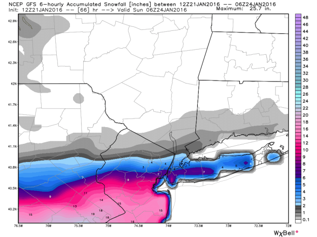
Notice in the image above possible snowfall from the storm. Nothing Hartford, inch or two New Haven to several inches of snow NYC. Check out double digit snowfall potential in New Jersey. That is a VERY sharp cut off in precip.
The cause of the sharp cut-off? A strong, cold area of high pressure (dry air) is banked to our north. It is also stuck there thanks to the upper level wind pattern. The ironic thing is for snow fans, this is something that has been absent all winter causing rain storms rather than snow storms.
Can the storm still shift? YES. If it shifts even 40, 70 miles, that would make a BIG difference for many towns on Saturday.
WHAT YOU NEED TO KNOW: It may take until the afternoon to get any snow in northern CT, where as Southern CT could start the snow during the morning (especially through Fairfield County). Any snow that does happen, likely ends by Sunday morning.
Northern CT may need a broom to clear snow. People through the shoreline could still be looking at a plowable snow (Plowable generally means 2″+).
Air travel: If you have air travel anywhere along the east coast or connections, change those plans as soon as possible. HUGE travel disruptions are possible.
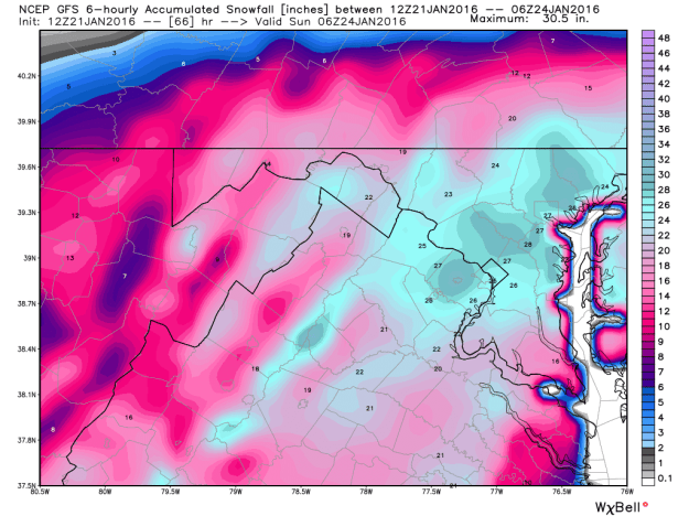
Check out where the target appears to be, Washington DC. This is one estimation of what could fall. It is looking like a possible epic storm for the DC Metro and surrounding area. Look at those totals!