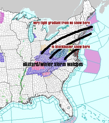
The weekend storm continues to evolve, but we’re starting to get SOME sense of where the bulls eye for snow will end up. Right now, that target appears to be south of Southern New England (Sorry snow fans).
Cold high pressure to the north will help to create a very sharp cut off (see map above and below).

What we know as of now (Wednesday AM):
Expect a HUGE interruption in travel for the the east coast.
Mid-Atlantic is looking like the target for epic snow and wind (1-2FEET possible)
Southern New England sees plowable snow (several inches possible) but the farther north you go the less snow you get. There could be a huge difference between the CT Shoreline and the Mass. Pike.
Timeline: Snow looks to develop during the day Saturday. Heaviest Saturday night, wrapping up early Sunday.
We will know MUCH MORE after seeing ALL of the data that comes in today. While, at this time, we’re not forecasting a blockbuster snowstorm for us in Southern New England, we have to watch to see if there are any trends north or south today and tomorrow as that will have a HUGE impact on our forecast.
Stay tuned…
