1-3″ of rain expected Tomorrow into tomorrow night.
As I posted last week and updated over the weekend, a strong coastal storm is expected to form and move up the coast.
Multiple advisories are in place, from Winter weather, coastl flood, flood watches, wind and more. See ALL advisories here: ADVISORIES/WATCHES/WARNINGS
The details: The wind pattern will help to pull the storm close to the coast, that means we’ll see warmer ocean air dominate the storm. A wintry mix will likely break out tonight, but trend toward rain quickly.
Wintry Mix: It sure is cold today, but expect the atmosphere to slowly warm. We could start with some freezing drizzle tonight and some scattered areas of light snow breaking out. As the heavier precip moves in expect a change to rain. Before that happens, expect plenty of slippery travel during the overnight and likely for the start of the AM commute.
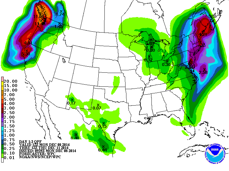
Rain: Expect heavy rain, with 1-3″+ inches possible. Check your sump pumps, this is the time of year we see big basement flooding with storms like this, thanks to frozen ground (the water has no where to go, except basements, streets, etc.)
Wind: Wind gusts will peak during the Tuesday and Tuesday night time frame with gusts frequently 20-40 MPH. Higher gusts are likely.
The storm (the upper level low) will basically stall across the northeast this week, that means plenty of clouds, on and off rain and snow showers. By far, the biggest part of the storm will take place Tuesday and Tuesday night.
See the above map for expected rainfall. Also, you may want to check the sump pumps, this time of year we have the issue of frozen ground and heavy rain. That combo sends water into basements, etc. Also a good time to clear storm drains of leaves.
It’s going to be a classic rain storm, with some heavy snow JUST up to our north.
